
How to Correct Your Depth Sounder Reading for Sailing Safety
How can you convert a depth sounder reading to the depth shown on your nautical or electronic chart? Use this sailing navigation secret to keep your small sailboat in safe water. Read on for a fast 'n easy sailing solution.
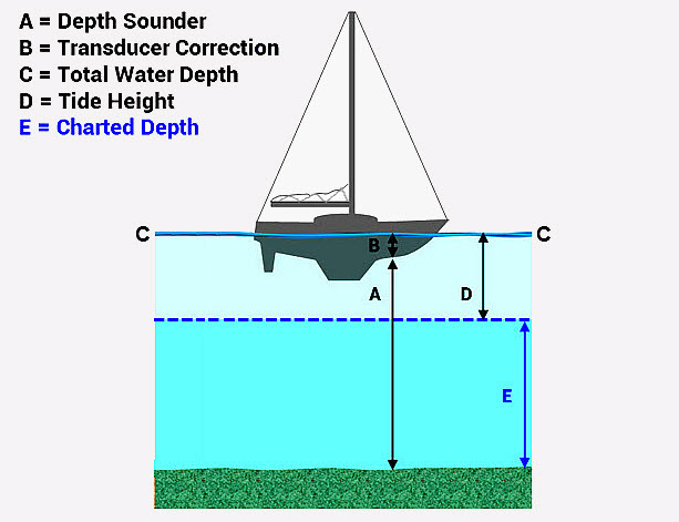
A site member recently asked if there was a way to correct the depth from a depth sounder to the depths shown on a nautical or electronic chart. It's a great question and super important to know for sailing safety. Use the three steps below along with the illustration to help you:
- Sail down a depth curve to a buoy or beacon.
- Compare your GPS with the charted depth.
- Make safer landfall in fog or nighttime.
- Follow a "line of soundings" to find your way.
- Add strength to an estimated position (EP).
1. Find the sounding units and depth datum on your chart. Look beneath the title block. Units will be shown in feet, fathoms or meters. You'll also find units in all CAPS in the white borders of your nautical chart. Depth Datums are in Mean Lower Low Water (MLLW) for US charts. International charts often use a much more conservative datum such as Lowest Astronomical Tide (LAT), or the lowest theoretical tide for that area.
2. Open a Tide Table or consult a tide graph for your sailing or cruising area. Compute the tide height for the desired time. Apply the tide height correction to the depth datum. In US waters or on charts that use MLLW as the datum, tide heights may be above or below the datum. On charts outside of US waters or on charts that use LAT as the datum, tide heights are always above the datum. Go to the next step.
3. Measure the distance that your depth sounder transducer was installed below the waterline. Use a measuring tape or ruler. Make an entry into the navigation log to show your measurement. That way, you have a permanent record for future reference. To find the Total Water Depth, add your transducer correction to the depth sounder reading. Work through the example below. Use the illustration as a guide.
SAILING SCENARIO:
You are cruising in the Chesapeake Bay. Soundings are in feet at Mean Lower Low Water (MLLW). Your depth transducer is installed two feet below the waterline. The depth sounder reads sixteen feet. The tide tables show a tide height correction of five feet above MLLW. Your latest position on the chart shows that you are in 13 feet of water. Correct the depth sounder reading and compare it to the charted depth. They should be the same or close if you've done things right.
(NOTE: letters correspond to the illustration)
A--Depth Sounder Reading: 16 feet.
B--Transducer Correction: + 2 feet.
C--Total Water Depth: 18 feet.
D--Tide Height Correction: - 5 feet.
E--Calculated Charted Depth: 13 feet.
Compare your calculated charted depth to the charted depth at this position: 13 feet. Now you have another navigation method to strengthen your confidence in the latest GPS position. This applies to any type of position (dead reckoning; visual; electronic; celestial). Always use at least two types of position finding for sailing safety.
~~~~~~~~~~~~~~~~~~~~
Captain John's Sailing Tip
You might wonder why we subtracted our tide height, which was five feet above datum. Here, we want to work backward to find the actual charted depth. So, we "reduced"--or subtracted--the tide height from total water depth. Navigators refer to this technique as a "reduction to soundings".
~~~~~~~~~~~~~~~~~~~~
Use these easy sailing navigation tips to give you the edge when sailing in inland or coastal waters. Keep your sailing crew and small sailboat safe and sound this season and for many seasons to come--wherever you choose to sail or cruise.
>> Click Here to Learn More About the Benefits of Skippertips Membership <<