
How to 'Sail a Coastline' with Radar Navigation
What electronic navigation instrument gives the sailing skipper the ability to navigate into a fogbound cove with confidence, avoid a collision with small craft or ships, and track a squall line to avoid storm force winds--all in one compact package? Read on to find the answer.
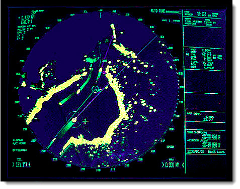
"Keep her two miles off the beach!" Those were the Captain's directions, as stated in his Night Orders. And you can bet, if that's what "the man" wanted, that's what he got. Done deal. We were on a U.S. Coast Guard mission off the coast of New Jersey. Shoals were just a few hundred yards away. And with a draft of 12 feet, we needed to be on our toes. Rain and fog added to the challenge. What technique would make this tough task safer and easier?
To this day, I consider the most important electronic navigation instrument to be the radar. Indeed, GPS ranks high on the list, but no other instrument offers the sailing skipper the multi-task ability to navigate, avoid a collision, track squalls or storm systems and provide a shoreline picture in real-time--all in one package.
Your marine radar sends a signal out from the antenna. When the signal strikes an object, it reflects the signal back to the onboard receiver. Your radar determines the distance (called "range" in radar-speak) to an object based on the time it takes (in fractions of a second) for the signal to travel from the antenna to the object and back again.
It's all based on the reflective strength of the object. Large, bold surface areas such as ship hulls and superstructure offer better reflectivity than low-to-the-water sailboat hulls and skinny masts. Sails have poor reflective qualities. That's a good reason to always hoist one or two radar reflectors when sailing or cruising in coastal or offshore waters.
Land mass with bold headlands like cliff walls or well-defined beaches with dunes provides better reflectivity than inter-tidal areas (i.e. green-tinted areas) on your chart. Squalls and storm clouds are compact, lower to the earth and contain a heavy concentration of water droplets with excellent reflectivity. These clouds show up as air-brushed blobs on your radar scope. Track them just like you'd track a ship to determine the best action to avoid "collision".
The modern marine radar gives you two ways to measure distance. Fixed range markers are concentric circles, staggered at specific intervals. For example, if you set the radar to the six-mile scale, fixed range rings might appear at two-mile intervals. If you change to the twelve-mile scale, fixed range rings may be shown at three-mile intervals.
The Variable Range Marker (VRM) gives you the most control. Instead of fixed rings, the VRM shows a single range ring or--on some radars--just a small dot of intense light. You use the radar keypad or control knob to move the VRM "bug" from the scope center out to the target. Read the range in nautical miles and tenths.
How to Use Radar's Secret Super Tool
Let's return to the opening scenario. The New Jersey shore runs flat for miles and miles in a lazy northeast/southwest direction. So, it's a simple matter to run the VRM out to the desired range, in this case, 2.0 nautical miles. Watch the VRM circle relative to the coastline. Adjust the ship's course to maintain the desired distance. Follow the illustrations along with the steps shown below.
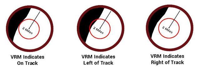
In the far left illustration above, we move the VRM out to the two-mile range and leave it there. Note how it just touches the land profile shown on the radar scope. In the middle illustration, the wind, current or steering error sets us a bit too close to land. We change course to seaward until once again, the VRM just kisses the shoreline (far left illustration).
In the far right illustration, the elements have pushed us a bit too far offshore. Change course toward the coast until, once again, the VRM circle or bug touches the profile of the shoreline. Realize that this represents one method of navigation. Add soundings along with visual bearings (if available) to confirm your position for coastal sailing safety.
~~~~~~~~~~~~~~~~~~~~
Put the power of today's modern electronics into play aboard your small sailboat with easy navigation tips like these. This will give you the confidence to use all of the navigation tools at your fingertips for safer sailing or cruising worldwide.
Click Here to Discover the Benefits of Skippertips Membership